Barrie’s development arc, from a key stop on the Nine Mile Portage to one of Canada’s fastest-growing cities, has placed intense demand on its glacial landforms. The Kempenfelt Bay shoreline and the rolling till plains that stretch toward the Simcoe Uplands create a patchwork of subsurface conditions, where sand lenses, silty clay deposits, and occasional cobble beds alternate within a single building lot. For contractors and developers working near the waterfront or in south-end subdivisions, an exploratory test pit provides immediate visual confirmation of stratigraphy before heavy equipment moves in. Unlike deep drilling, which targets bedrock competence, a test pit lets our team document soil fabric, moisture content, and seepage patterns right at footing depth, which is often the critical zone for frost protection and bearing capacity under Part 9 of the Ontario Building Code. When the excavation reveals organic silt or uncontrolled fill—common in older sections of downtown Barrie—we can recommend extending the investigation with test pits to map the lateral extent of the problem material before the foundation design is locked in.
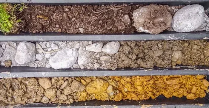
A two-metre-deep test pit reveals more about Barrie’s glacial stratigraphy than a dozen borehole logs without visual context.
Process overview
Local context
The excavator bucket breaks ground, and within the first metre we can already read the site history. In Barrie, where the water table often sits high in spring due to snowmelt recharge, an unshored test pit can become a hazard quickly if sidewalls start sloughing in saturated silt. We use trench boxes or benched slopes per Ontario Regulation 213/91 requirements, and our field lead checks atmospheric monitoring when pits exceed 1.2 metres, not because we expect gas, but because confined spaces near old landfill cells or swampy backfill can hold depleted oxygen. The physical exposure also reveals buried obstructions—concrete rubble from demolished farm structures, old weeping tile lines, or abandoned service laterals—that no desktop utility locate will flag. Skipping this step because a borehole log says “sand to 3 metres” misses the lens of compressible peat that the auger churned through without capturing. A well-documented exploratory test pit, photographed and logged at 20 cm intervals, gives the geotechnical engineer a calibrated field observation to anchor the borehole data, and it gives the contractor a realistic picture of what the excavator will actually encounter during bulk excavation.
Visual overview
Relevant standards
ASTM D2488-17e1, Ontario Building Code (O. Reg. 332/12) Part 9, CSA A23.3 (concrete in contact with sulfate soils)
Additional services
Residential Footing Inspection Pit
A single or double pit excavated at proposed footing locations to document soil type, groundwater presence, and bearing stratum consistency. We provide a signed field log with photographic record suitable for building permit submission under Part 9 of the Ontario Building Code.
Commercial Pre-Design Exploratory Program
Multiple pits laid out on a grid covering the building footprint, supplemented by hand penetrometer readings and bulk sampling for laboratory index testing. This package is designed for low-rise commercial structures where shallow foundations are anticipated, giving the design team a clear picture of allowable bearing pressure and excavation conditions.
Stormwater Infiltration Test Pit
Pit excavated to proposed infiltration facility depth, with double-ring infiltrometer testing conducted directly in the exposed soil horizon. We document soil texture, mottling, and restrictive layers that control percolation rate, supporting SWM design submissions to the Lake Simcoe Region Conservation Authority.
Typical parameters
Top questions
How deep do you typically excavate an exploratory test pit in Barrie?
Most pits in the Barrie area go to 2.4 or 3.0 metres, which gets us past the frost line and into the bearing stratum for typical residential footings. We can go deeper with benching or a trench box, but the practical limit with a mid-size excavator on residential lots is usually around 4.5 metres before groundwater becomes the controlling factor.
What does an exploratory test pit cost for a standard residential lot in Barrie?
For a single-family residential lot, budget between CA$760 and CA$1,160 depending on access, number of pits, and whether we need to bring in a trench box. That range includes equipment time, field logging, photo documentation, and a signed report suitable for your building permit application.
Do I still need a full geotechnical report if I get test pits done?
It depends on your project scope. For a single-family home under Part 9, a well-documented test pit log with bearing recommendations often satisfies the municipality. Larger commercial projects or anything on engineered fill will typically need borehole data and laboratory testing alongside the pit observations to meet the full geotechnical report requirements.