Geotechnical site investigation is the essential first step in understanding the ground conditions beneath any proposed development in Barrie. It encompasses a range of field and laboratory techniques designed to characterize soil, rock, and groundwater, providing the data engineers need to design safe and cost-effective foundations. In a city experiencing rapid residential and commercial growth, skipping this phase can lead to structural distress, costly delays, or even catastrophic failure. The investigation process not only identifies bearing capacity and settlement potential but also flags environmental concerns such as contaminated soils or methane gas, which are increasingly common in redeveloped urban lots.
Barrie’s geological setting presents a unique set of challenges that make thorough investigation non-negotiable. The city sits on the southern edge of the Canadian Shield, underlain by Ordovician limestone and shale bedrock, but much of the urban area is draped in thick deposits of glacial till, glaciofluvial sands, and glaciolacustrine silts and clays left by Lake Algonquin. These soft, compressible clay layers, particularly in the low-lying areas near Kempenfelt Bay and the former shorelines, are prone to long-term settlement and can exhibit low shear strength. Additionally, the water table is often high, and artesian conditions can be encountered where permeable sand layers are confined beneath clay, complicating excavations and requiring robust dewatering plans.
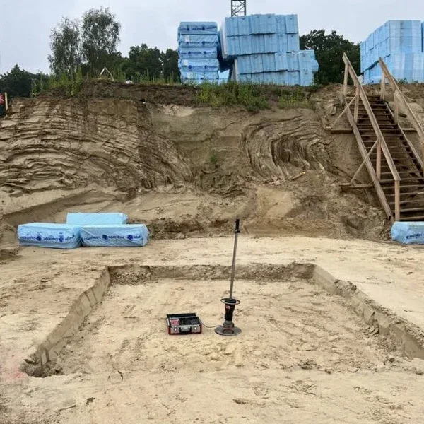
In Ontario, geotechnical investigations are governed by the Ontario Building Code (OBC), which mandates that foundation designs be based on adequate subsurface information. Engineers must adhere to the Professional Engineers Act and typically follow guidelines from the Canadian Foundation Engineering Manual (CFEM) and ASTM International standards for field testing and sampling. For public infrastructure projects, the Ministry of Transportation Ontario (MTO) specifications often apply. A key in-situ test for Barrie’s sensitive clays and silts is the CPT (Cone Penetration Test), which provides near-continuous profiling of soil stratigraphy and pore pressure, delivering high-resolution data critical for assessing liquefaction potential and designing deep foundations in weak deposits.
The types of projects requiring comprehensive investigation in Barrie are diverse. Low-rise residential subdivisions on greenfield sites need to confirm bearing capacity and identify pockets of organic soil or fill. Mid-rise and high-rise condominium developments, particularly those near the waterfront, rely on deep borings and CPT (Cone Penetration Test) soundings to design deep pile foundations that bypass soft clays and bear on competent till or bedrock. Industrial and commercial warehouses with heavy floor loads demand rigorous settlement analysis, while infrastructure like road widenings, bridge replacements, and stormwater management ponds must evaluate slope stability and seepage. Even smaller infill projects in established neighborhoods benefit from targeted testing to avoid surprises from historical fill or undocumented buried structures.
Available services
Common questions
When is a geotechnical investigation required for a building permit in Barrie?
Under the Ontario Building Code, a geotechnical investigation is required whenever a foundation is designed, especially for structures exceeding 600 square meters or three storeys. The City of Barrie typically mandates submission of a soils report with permit applications for most commercial, industrial, and multi-residential projects, as well as single-family homes in areas with known sensitive soils or high water tables.
What types of soil conditions in Barrie most often cause foundation problems?
The glaciolacustrine clays and silts deposited by glacial Lake Algonquin are the primary concern. These deposits can be deeply buried, normally consolidated, and highly compressible, leading to significant settlement under load. Loose, saturated sand lenses within these clays also pose a liquefaction risk during seismic events, while the generally high groundwater table complicates excavations.
How deep do site investigation boreholes typically go in the Barrie area?
Borehole depth depends on the structure and ground conditions. For a typical low-rise building on spread footings, depths of 6 to 10 metres below footing level are common to check for weaker layers. Where deep foundations such as piles are required to bypass soft clays and reach competent till or bedrock, boreholes often extend 20 to 30 metres or more. The Ontario Building Code provides minimum depth guidelines based on foundation width and loading.
What is the difference between a standard borehole program and a CPT investigation?
A conventional borehole program retrieves disturbed and undisturbed samples for visual classification and laboratory testing, providing direct measurement of soil properties. A CPT, or Cone Penetration Test, pushes an instrumented cone into the ground at a constant rate, continuously measuring tip resistance, sleeve friction, and pore water pressure. CPT offers a rapid, high-resolution profile without samples, making it ideal for delineating soft clay layers, sand seams, and for assessing liquefaction potential in Barrie’s complex glacial stratigraphy.